
15 Private Places to Propose in New Jersey:
Secluded Gardens, Beaches & Hidden Gems
A quieter place. A little breathing room. A moment that feels like the two of you. These nearby gardens, trails and shorelines are worth scouting before you ask the question.


You do not need a crowd, a dramatic production or a long drive to make a proposal memorable. Sometimes the right setting is a garden path, a familiar walk through the woods or a stretch of beach with enough room to hear each other.
This guide stays close to home: every location is in New Jersey and within a 30-mile straight-line radius of the Middletown reference point described below. Driving distances will be longer. For a sense of how real moments unfold, browse Delgado Studios’ proposal stories.
Three ways to make it yours
A garden moment
Deep Cut Gardens for formal planting; Holmdel Park for a tree-filled setting.
A walk, then a question
Tatum, Huber Woods or Hartshorne for a natural, unhurried outing.
Room beside the water
Sandy Hook for the ocean; Perrineville Lake for a countryside mood.
Garden
Middletown
Approx. 3.3 miles straight-line
Deep Cut Gardens
For a proposal with a garden-party feeling, start here. The formal rose parterre gives you structured greenery and stonework; the shade garden offers a softer, more enclosed setting. Seasonal planting changes the mood, so choose the background you love rather than planning around a bloom that may not arrive on schedule.
The privacy reality
The rose garden is a destination within a popular public garden. Its tucked-away appearance does not mean you will have it to yourselves.
Scout this before you go
Scout just after the published 8 a.m. opening on a weekday. Compare the parterre with the shade-garden walkway, and choose a second stopping point in case visitors are already at your favorite spot. Check steps and footing in the shoes you will wear.
Official location details, map and current notices ↗
See a real example in Kevin and Deanna’s Deep Cut Gardens proposal.
Woodland
Middletown
Approx. 3.3 miles straight-line
Tatum Park
Tatum is a good match for a proposal that feels like an ordinary walk becoming something extraordinary. Rolling fields and wooded trails create a less formal alternative to nearby Deep Cut Gardens. A place where a maintained path meets an open field can give you both a natural backdrop and room to pause.
The privacy reality
Activity centers, the playground and shared trails bring other visitors. A quiet field edge may still be visible from a passing trail.
Scout this before you go
Use the Red Hill Road entrance when comparing Tatum with Deep Cut. Walk your chosen route in both directions, time the return, and test whether the field edge becomes muddy after rain. Pick an existing open area without stepping into tall vegetation.
Garden & park
Holmdel
Approx. 6.5 miles straight-line
Holmdel Park
Holmdel pairs open parkland with the David C. Shaw Arboretum, making it a useful choice for couples drawn to trees and seasonal color. The setting can feel intimate when you frame the moment around a particular tree or a quieter stretch of path rather than a broad, busy lawn.
The privacy reality
This is an active recreation park. Cross-country meets, family visits and activity around Longstreet Farm can quickly change the atmosphere.
Scout this before you go
Check the event calendar before choosing a date. Scout the arboretum and nearby paths separately from the farm entrance, then listen for crowd noise as well as checking the view. Keep a second location ready during fall running season.
Woodland
Locust / Middletown
Approx. 2.4 miles straight-line
Huber Woods Park
Huber Woods suits couples who would rather hear leaves moving than traffic or a restaurant crowd. Meadows and wooded trails provide a relaxed countryside feeling close to Middletown. Consider a short walk with a deliberate stopping point, keeping the experience comfortable enough that the surprise remains the focus.
The privacy reality
The environmental center draws visitors, and the trails are shared with other recreation users. A bend in the path provides visual separation, not exclusive use.
Scout this before you go
Scout beyond the immediate center area on a marked route. Check the gradient, how much light reaches faces under the canopy, and whether your photographer has a clear view without standing in vegetation. Review current seasonal closure notices.
Woodland
Highlands / Middletown
Approx. 4.6 miles straight-line
Hartshorne Woods Park
Hartshorne brings a more adventurous mood: wooded hills, winding trails and a landscape shaped by the Navesink River. It makes sense when walking together is already part of your relationship. Keep the proposal on a comfortable section of an established route rather than turning the search for a view into a strenuous expedition.
The privacy reality
Hikers and mountain bikers share the park. Narrow paths, popular viewpoints and historic military features are poor places to count on uninterrupted time.
Scout this before you go
Enter at Rocky Point and use the official map to choose a short out-and-back. Test the uphill return and avoid stopping on blind bends. Scout while there is ample daylight; wooded hills can lose usable light before an open beach does.
Meadow & lake
Lincroft
Approx. 6.2 miles straight-line
Thompson Park
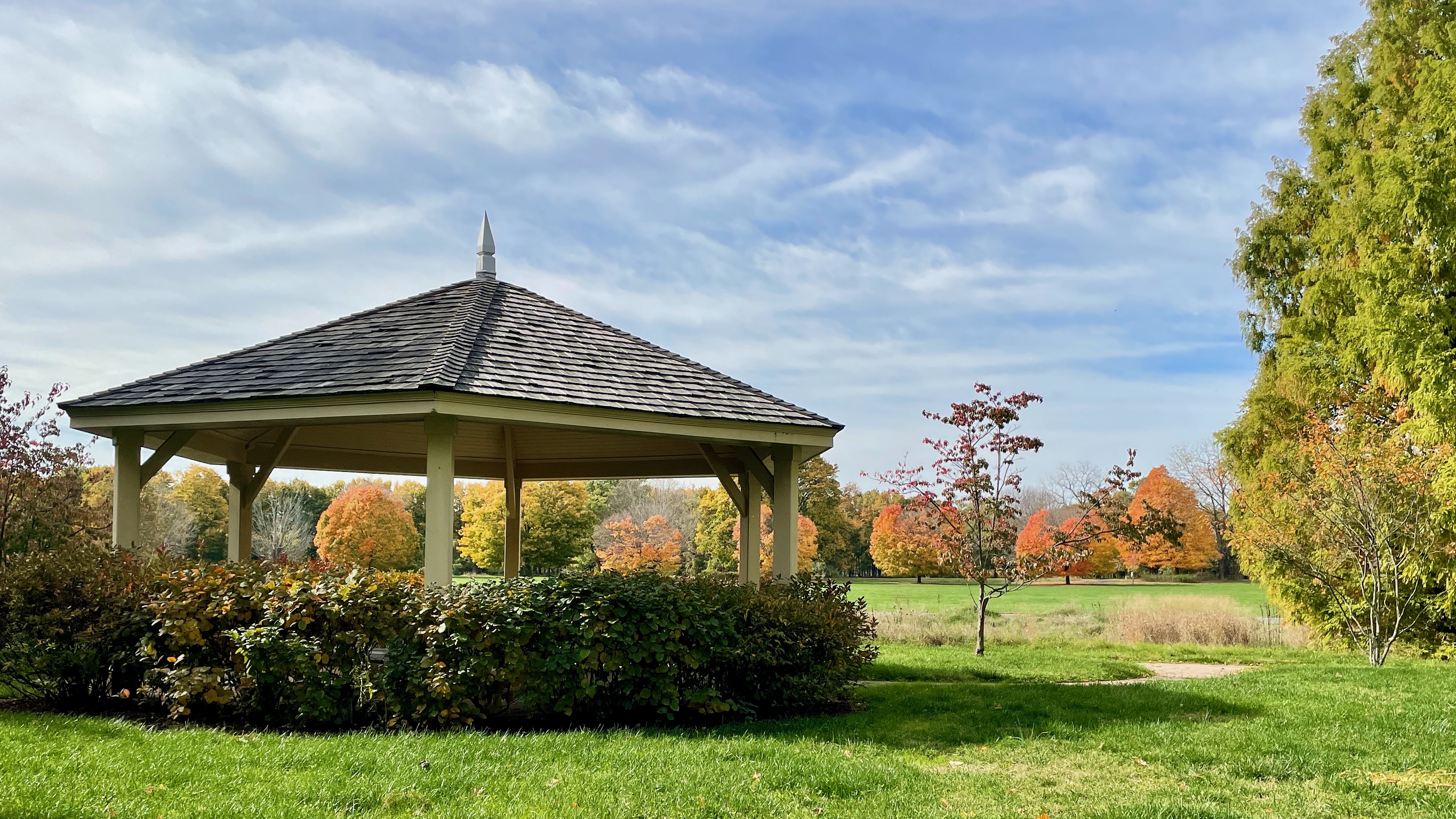
Thompson offers an estate-like landscape, broad open spaces and Marlu Lake within a large county park. It is especially useful when you want options: a pastoral background for the question, followed by a few portraits elsewhere on the grounds. This is the Thompson Park in Lincroft, not the park of the same name in Middlesex County.
The privacy reality
Lake access, programs, dog walkers and seasonal events can concentrate visitors. A gazebo or picturesque lawn is a shared amenity, not a private room.
Scout this before you go
Use the park map to compare a lake-side route with the open grounds near the historic buildings. Check how far each is from your actual parking space. Avoid event days and review the posted hunting closures before committing to an early arrival.

Open landscape
Colts Neck
Approx. 7.9 miles straight-line
Dorbrook Recreation Area
Dorbrook is a practical option for a simple walk with open-sky portraits. Its paved north-side trail has two loops, giving you a way to look for an uncluttered background without planning a woodland hike. Choose it for convenience and an easygoing feel rather than deep seclusion.
The privacy reality
This is an active park with a playground, sports facilities and a seasonal sprayground. It belongs on the shortlist only if you can find a quiet window away from those hubs.
Scout this before you go
Walk the north-side loops on a weekday and compare the stretches farthest from play areas. Listen for activity on adjacent fields. Check the exact surface and distance for anyone with mobility needs; do not assume the entire route suits every visitor.
Meadow & woodland
Marlboro
Approx. 10.0 miles straight-line
Big Brook Park
Big Brook Park offers fields of grasses and perennials alongside wetland and maturing woodland. The appeal is understated: seasonal texture, a simple trail and a backdrop that does not compete with the moment. This entry is the county park in Marlboro, not a recommendation to enter a creek or a different fossil-collecting site.
The privacy reality
Trail users and activities elsewhere in the park may interrupt a quiet spell. Wetland edges should not be treated as informal photo clearings.
Scout this before you go
Start at the Route 520 entrance and find a maintained path with a field beyond it. Visit after weather similar to your forecast to assess mud. Stay on established routes and review seasonal hunting boundaries before planning.
Woodland
Oakhurst
Approx. 9.7 miles straight-line
Weltz Conservation Area
Weltz offers a pocket of woodland in a developed part of Monmouth County. Upland forest and wetter lowland habitat make it a candidate for couples who prefer a quiet, green background to a landmark. Think of it as a neighborhood nature escape, with the proposal built around a brief walk.
The privacy reality
The conservation area includes an off-leash dog area. Nearby activity and passing walkers can make the entrance less peaceful than the wooded setting suggests.
Scout this before you go
Locate the dog-area approach first, then scout a separate marked walking route. Check for wet ground and an open patch of light along the path. Protect the habitat by keeping both the couple and photographer on established surfaces.
Woodland & pond
Wall
Approx. 14.0 miles straight-line
Shark River Park
Shark River Park is a woodland alternative to the nearby shore. Trails and the pond area let you plan a proposal with a softer, sheltered feeling instead of an exposed ocean horizon. It works best when the walk itself feels natural to you both and you are happy to keep the setting simple.
The privacy reality
Picnic areas, a playground and group gatherings can bring conversation and activity into the quieter-looking scenery.
Scout this before you go
Compare the pond area with a short marked trail away from picnic facilities. Check whether a gathering is scheduled, inspect the footing after rain and choose a place wide enough to pause without blocking other visitors. Confirm seasonal access before your visit.
Lake & woodland
Freehold
Approx. 19.5 miles straight-line
Turkey Swamp Park
A lake surrounded by pine-and-oak woodland gives Turkey Swamp a retreat-like character. This is a strong option for couples who like camping, easy nature walks or the idea of a lakeside moment. The landscape is more rustic than manicured, so comfortable shoes belong in the plan.
The privacy reality
The lake is a recreation destination, with campers, anglers, boat rentals and picnic visitors. Quiet surroundings do not make the shoreline empty.
Scout this before you go
Use the main park entrance, not the separate group campground. Scout an existing lakeside stopping point away from boat activity and test the ground carefully after rain. Allow time to walk back before closing rather than relying on a last-minute sunset exit.
Lake & countryside
Millstone
Approx. 22.9 miles straight-line
Perrineville Lake Park
Perrineville is the countryside choice on this list: a lake, wooded surroundings and a quieter visual palette than a boardwalk or formal garden. It is worth considering when you want the outing to feel a little removed from everyday life while staying inside the Middletown radius.
The privacy reality
Anglers and paddlers use the lake, and the park has several separate access points. A peaceful-looking shoreline is not necessarily a place where you can stand.
Scout this before you go
Begin at the designated lake access on Perrineville Road, then inspect where visitors can safely pause without obstructing launching or fishing. Do not assume the Baird Road trailhead leads directly to your chosen water view. Save the correct entrance before leaving home.
Waterfront
Howell
Approx. 17.2 miles straight-line
Manasquan Reservoir
The reservoir offers a wide expanse of water framed by woods and wetlands. Its five-mile perimeter trail gives you opportunities to scout different views, but you do not need to complete the loop for a proposal. Plan a short route to a suitable existing stopping place and enjoy the water as the backdrop.
The privacy reality
This is a heavily visited park, not a hidden lake. The main visitor area and perimeter trail may be busy even when the scene looks serene.
Scout this before you go
Start from the Visitor Center and identify a short out-and-back that avoids the boat-launch flow. Check wind direction and face lighting. The Environmental Center was listed as closed for renovation when researched; do not rely on that building as your meeting point or rain backup.
Ocean beach
Middletown / Gateway NRA
Approx. 4.9 miles straight-line
Sandy Hook — Beach D
For a proposal with sand, surf and a long ocean horizon, consider Beach D outside the busiest beach hours and season. The spare landscape keeps attention on the two of you. It is a particularly good fit if walking along the shore already feels like your kind of date.
The privacy reality
Beach D is a popular summer swimming beach. Even a cool weekday can bring walkers; dunes and closed wildlife areas are never shortcuts to privacy.
Scout this before you go
Use the designated beach access and scout on a day with comparable wind and tide. Time the walk from parking to firm, open sand, then pick a backup if the beach is exposed or crowded. On this east-facing ocean shore, sunset light does not mean the sun will set over the water.


Inlet beach
Manasquan
Approx. 20.5 miles straight-line
Fisherman’s Cove Conservation Area
Fisherman’s Cove offers an inlet-side alternative to an ocean beach, with natural shoreline and boats passing through the wider setting. It suits a relaxed, coastal proposal rather than an elaborate setup. The water and sandy textures can make the moment feel distinctly Jersey Shore without putting you on a boardwalk.
The privacy reality
Anglers, leashed dogs and other beach visitors share the space. Boat activity can be audible, and habitat-restoration work may affect where you can walk.
Scout this before you go
Check the tide and inspect the usable beach at a similar tidal stage. Locate the designated conservation-area parking spaces and read their time limits. Keep clear of fishing lines, restoration areas and narrow stretches where people need to pass.
Give the moment a little room
Pick two stopping points within the same location. One might be your favorite background; the other is your fallback if someone is already there. Visit at the same weekday and approximate time you are considering, and spend a few minutes watching how people move through the space.
Walk the full route from parking, check how shoes handle the surface, and decide where your photographer can see both faces without obstructing a path. For beaches, compare tide and wind conditions. For woods, leave more daylight than you think you need. A familiar route and a simple backup often do more for a relaxed proposal than a complicated setup.
Before leaving, open the official location link for current hours, access notices and closures. Several county parks have seasonal hunting closures; a quiet-looking trail is not evidence that it is open. Stay on public paths and open beach, and leave planted beds, dunes and restoration areas undisturbed.
A few questions couples ask
Which place gives us the best chance of privacy?
There is no guaranteed winner. Start by scouting a short woodland route at Tatum or Huber Woods on a non-holiday weekday. Deep Cut can feel intimate but attracts garden visitors, while Sandy Hook and Manasquan Reservoir are popular destinations. Choose a time and backup point before choosing a “perfect” background.
Are these all within 30 miles of Middletown?
Yes, measured straight-line from the stated Middletown reference coordinate to representative points at each site. This is not a driving-distance list. The distance audit below shows the coordinates and sources used.
Can we plan around sunset?
Only if the location’s closing time, walking distance and available light allow it. Forest shade arrives early, and a sunset sky is different from seeing the sun set over water. Scout your exact viewpoint and allow a comfortable exit before closing.
What if we want complete privacy?
A public park cannot promise that. Consider a private property or venue where exclusive access is expressly arranged with the owner. The places in this guide are options for an intimate atmosphere while sharing public space.
Let’s talk about the question you’re going to ask.
Share your date, the setting you love and what would help you both feel comfortable. Start with real proposal stories, then tell Delgado Studios what you have in mind.
Talk with Joseph about your proposal →Sources & distance check
Each location’s official page is linked in its entry. Distances use the haversine formula with an Earth radius of 3,958.7613 miles, rounded to one decimal place. The origin is the published Middletown Township reference coordinate, 40.404786, −74.071404. Site coordinates are representative park, facility, shoreline or photograph-location points; they are not exact proposal positions or navigation instructions. All are comfortably inside the 30-mile limit.
View all 15 coordinates and calculated distances
| Location | Latitude, longitude | Straight-line miles | Coordinate source |
|---|---|---|---|
| Deep Cut Gardens | 40.389834, -74.13 | 3.3 | Source |
| Tatum Park | 40.390403, -74.130942 | 3.3 | Source |
| Holmdel Park | 40.368955, -74.185306 | 6.5 | Source |
| Huber Woods Park | 40.3859, -74.0337 | 2.4 | Source |
| Hartshorne Woods Park | 40.38967, -73.98631 | 4.6 | Source |
| Thompson Park | 40.331847, -74.140572 | 6.2 | Source |
| Dorbrook Recreation Area | 40.301145, -74.136868 | 7.9 | Source |
| Big Brook Park | 40.3267764, -74.2318114 | 10.0 | Source |
| Weltz Conservation Area | 40.26679, -74.03667 | 9.7 | Source |
| Shark River Park | 40.2028908, -74.0912509 | 14.0 | Source |
| Turkey Swamp Park | 40.188025, -74.308868 | 19.5 | Source |
| Perrineville Lake Park | 40.2251883, -74.4374162 | 22.9 | Source |
| Manasquan Reservoir | 40.178775, -74.207239 | 17.2 | Source |
| Sandy Hook — Beach D | 40.425513, -73.98319 | 4.9 | Source |
| Fisherman’s Cove Conservation Area | 40.1087264, -74.0395812 | 20.5 | Source |
Additional planning source: National Park Service visitor updates for Gateway, including Sandy Hook. Current conditions, plant displays and visitor patterns can change after this research date.
About the photographs and their licenses
All three photographs are externally hosted Wikimedia Commons location references. They are not Delgado Studios photographs, do not show client proposal sessions, and do not imply endorsement by their creators. Credits, file-description links and license links appear directly below each image. The originals are displayed without cropping or other edits. The Thompson Park photograph remains available under CC BY-SA 4.0; that license applies to the photograph, not the original article text. Photo dates: Deep Cut Gardens, June 8, 2010; Thompson Park, October 28, 2022; Sandy Hook, September 5, 2013. These historical images illustrate the settings, not current access or conditions. Internet access is needed to load the hosted photos.